Trekking in Val d'Elsa: routes, trails, and the Via Francigena
The Val d’Elsa offers a varied and largely uncrowded landscape for walking. The trails here pass through vineyard country, dense oak and chestnut woodland, medieval villages, and open hilltop terrain with long views over the Chianti and the Apennines.
This is not high-mountain hiking. The elevation rarely exceeds 600 metres. The terrain is rolling, the paths are generally well-marked, and the distances are accessible for most moderately fit walkers. A day on foot in the Val d’Elsa is restorative rather than demanding.
Trekking in Val d’Elsa
The Val d’Elsa is part of a broader network of walking routes that links Florence to Siena and beyond. The landscape alternates between agricultural land in the valley floor and mixed woodland on the surrounding hills.
The walking season extends from March to November. Summer midday heat can be intense on open terrain. Start early in July and August, aim to be at your highest point before ten in the morning, and rest during the hottest hours. Spring and autumn are the most pleasant seasons: mild temperatures, low crowds, and the landscape at its most expressive.
Winter walking is possible on most routes but the clay soil on unpaved tracks becomes very muddy after rain. Waterproof boots are essential from November to March.
Marked trails near Barberino
The trail network in the area around Barberino Val d’Elsa is maintained partly by CAI (Club Alpino Italiano) and partly by local authorities. The routes are waymarked with coloured blazes on trees and rocks.
The trail connecting Barberino Val d’Elsa to San Donato in Poggio, about 8 km southeast, passes through vineyard edges and light woodland. The elevation gain is modest. The trail is easy to follow and ends in one of the most intact medieval villages in the Chianti. The return journey can be made by the same path or by road for variety.
The circuit around Certaldo, about 12 km from Barberino, takes in the lower and upper parts of the town and the countryside between them. The upper town (Certaldo Alto) on its brick hill is visible from most of the circuit.
A longer route links Barberino to Tavarnelle Val di Pesa and on to Badia a Passignano, about 12 km to the northeast. This trail passes through the Chianti Classico vineyard landscape at its most characteristic: long rows of Sangiovese, farm tracks, and stone farmhouses.
The Chianti Classico hiking trail, marked as the route connecting Greve to Siena, runs broadly through this area. Sections of it pass within a few kilometres of Barberino and can be used as part of a circular day route.
The Via Francigena on foot
The Via Francigena is one of Europe’s great historic pilgrimage routes. It runs from Canterbury in England to Rome, passing through the Alps, the Po Valley, and Tuscany before descending toward Lazio.
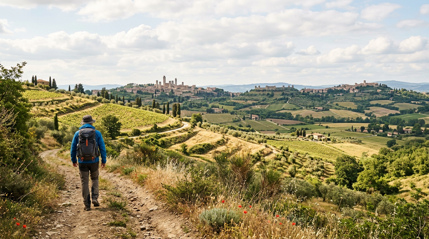
The Tuscan section, from Pontremoli on the Ligurian border to San Quirico d’Orcia, passes through Siena and the Val d’Elsa. The stretch between San Gimignano and Siena passes very close to Barberino Val d’Elsa and is among the most beautiful sections of the entire route.
San Gimignano is about 15 km northwest of Barberino. From there the Via Francigena heads southeast through Colle di Val d’Elsa, about 15 km from Barberino, and then on toward Siena. Walking the section from San Gimignano to Colle di Val d’Elsa and back is a full day of about 25 to 30 km, suitable for experienced walkers.
Shorter sections of the same route are accessible without the full commitment. The stretch from Colle di Val d’Elsa to Strove, about 10 km, passes through quiet Sienese countryside with minimal road walking. This is an excellent two to three hour walk on a clear day.
The Via Francigena is waymarked throughout with yellow signs bearing the Canterbury cross logo. The route is well documented and you can download GPS tracks from the official website.
Routes for all fitness levels
For easy walks of one to two hours, the perimeter trail around Barberino Val d’Elsa follows the edge of the historic town on partially unpaved paths with good views over the surrounding countryside. This is a good orientation walk for the first morning of a stay.
A moderate half-day walk of three to four hours could take you from Barberino to San Donato in Poggio and back, with a stop for lunch or a glass of wine in the village. The total distance is about 15 to 17 km with minimal elevation change.
For a full day route, the circuit from Barberino to Badia a Passignano, around the abbey, and back via a different path covers 20 to 25 km. The abbey and its surrounding vineyards add a strong cultural element to the walk.
More experienced walkers looking for a longer challenge can walk from Barberino Val d’Elsa to Greve in Chianti in a day. The distance is approximately 20 km with 400 metres of total elevation gain. The trail passes through some of the most photogenic vineyard landscape in Chianti Classico.
How to prepare for a day of trekking
Good footwear is the most important preparation. Trail shoes with ankle support and grip are adequate for most Val d’Elsa routes. Full hiking boots are recommended for the longer or more technical circuits in the Chianti hills.
Carry two to three litres of water for a full day walk. Drinking fountains (fontanelle) are present in most villages but absent on rural paths. Bring enough to last the full distance between settlement points.
A detailed paper map or downloaded GPS track is more reliable than phone signal in the Val d’Elsa hills. The Komoot and Wikiloc apps both have good coverage of Tuscan trails. The CAI website and regional trail databases publish free GPX files for many marked routes.
Inform someone of your planned route before setting out. This is basic safety practice on any trail, even easy ones.
Where to stay
Sogno d’Oro in Barberino Val d’Elsa is an ideal base for walking in the Val d’Elsa. You can step out of the guesthouse directly onto trail networks without needing to drive to a trailhead.
The surrounding countryside rewards slow travel on foot more than almost any other form. A few days here with a different trail each day gives you a complete and personal picture of this landscape.